Straddling the crest of Virginia's Blue Ridge Mountains, Shenandoah National Park stretches for nearly 75 miles from the town of Front Royal in the north, to the Waynesboro-Charlottesville area in the south. Although long in length, Shenandoah National Park varies in width - from a narrow strip of land of less than one mile, to roughly 13 miles.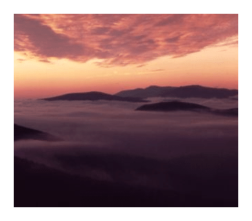 The peaks and overlooks of Shenandoah offer panoramic views of the Blue Ridge Mountains, as well as the patchwork of woods, farmlands and orchards in the valleys below. On the west side of the ridge is the broad Shenandoah River Valley, and on the eastern side are the rolling hills of the Virginia Piedmont.The park is perhaps best known for Skyline Drive, a 105-mile National Scenic Byway that runs atop the ridgeline along the entire length of the park. With 75 overlooks, the drive is especially popular in the fall when the leaves are changing colors.
Shenandoah was authorized in 1926, and was fully established as a national park on December 26, 1935 when the Commonwealth of Virginia transferred the deeds of the previous owners to the federal government. Prior to establishment much of the area was orchards and farmland. Today's visitors can still find many remnants of the old homesteads and farms throughout the park.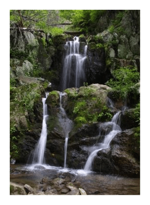 In 1976 Congress designated 79,579 acres (almost 40% of the total land area) in Shenandoah National Park as wilderness, which now offers visitors a variety of outstanding opportunities for recreation and solitude.Some of the many outdoor pursuits the park has to offer include hiking, backpacking, bicycling, horseback riding, camping, fishing and bird watching.
Within Shenandoah there are more than 200 species of birds, over 1300 species of plants, numerous waterfalls, and more than 60 peaks that top out above 2,000 feet in elevation, including Hawksbill Mountain, the highest point in the park at 4,051 feet.
More than 50 species of mammals live in Shenandoah, including black bears, bobcats, deer, coyotes and skunks. There have also been several unsubstantiated reports of cougar sightings in recent years as well.
Hiking in Shenandoah National Park
Shenandoah National Park is home to roughly 516 miles of trails, including 101 miles of the Appalachian Trail. Some trails lead to panoramic vistas, some to spectacular waterfalls, while others penetrate deep into Shenandoah's wilderness and offer solitude for hikers and backpackers.
Most trailheads are located along Skyline Drive. The major exception to this general rule is Old Rag Mountain, which is located on the north central edge of the park (near milepost 40).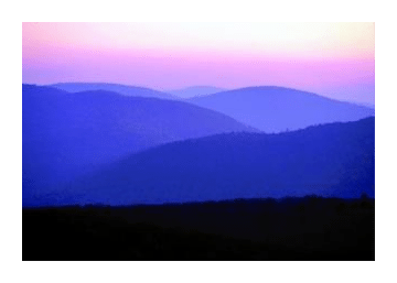 Some of the most popular hikes in Shenandoah include Compton Peak (at mile marker 10.4), Overall Run Falls (22.2), Stony Man (41.7), Whiteoak Canyon (42.6), Hawksbill Summit (46.7), Rose River Falls (49.4), Dark Hollow Falls (50.7), and Blackrock Summit (84.8).No question, the most popular hiking destination in the park is Old Rag Mountain. Unlike most of the mountains in the Blue Ridge, Old Rag stands alone as a separate peak, rather than as part of a continuous chain connected by ridges. The hike is very popular in all seasons, and can be extremely crowded on weekends. Old Rag's main attractions are the spectacular views from its summit, as well as the challenging scramble over rocks and boulders to reach the top. Consequently, Old Rag Mountain is also Shenandoah's most dangerous hike - as attested by the number of search and rescue missions conducted each year.
Below is a list of many of the trails and hikes in Shenandoah National Park. Starting from the north and moving south, each hike includes its Milepost location point, trail name, a brief description, roundtrip mileage, and total elevation gain. Note: some hikes can be made into one-way hikes if transportation is arranged.
Hikes in the North District
0.1 Dickey Ridge Trail (Overgrown fields, small stream) 2.7 miles/440 ft
4.6 Fox Hollow Trail (2 homesites, cemetery. Self-guiding, loop hike.) 1.2 miles/310 ft
5.1 Snead Farm (Orchard, barn) 1.6 miles/190 ft
9.2 Lands Run Gap to Hickerson Hollow (Homesites) 2.2 miles/940 ft
9.2 Lands Run Gap Road (series of small cascades) 1.3 miles/325 ft
10.4 Compton Gap to Fort Windham Rocks (geology) 0.8 miles/130 ft
10.4 Compton Gap to Indian Run Spring (solitude) 1.0 miles/165 ft
10.4 Compton Gap to Indian Run Spring & Fort Windham Rocks (Loop hike) 2.6 miles/340 ft
10.4 Compton Gap to Compton Peak (Views, geology-columnar jointing) 2.4 miles/835 ft
14.2 Jenkins Gap/Mt. Marshall/Bluff Trail (Outstanding views, loop hike) 12.8 miles/2495 ft
15.9 North Marshall (Views) 1.3 miles/295 ft
15.9 South Marshall (Views) 1.6 miles/295 ft
17.6 Gravel Springs Hut (Loop hike) 0.8 miles/190ft
17.6 Big Devils Stairs (Spectacular canyon, stream, cascades) 5.7 miles/1850 ft
19.4 Keyser Run Road/Piney Branch/A.T. (Views, loop hike) 6.8 mile/1145 ft
19.4 Keyser Run Road/Little Devils Stairs (Canyon, stream, cascades) 4.8 miles/1585 ft
19.4 Keyser Run/Little Devils Stairs (Canyon, stream, cascades, cemetery, loop) 7.7 miles/1845 ft
20.4 Hogback Summit (Views, loop hike.) 1.0 miles/250 ft
20.9 Hogback Overlook/A.T. (Views, loop hike) 0.7 miles/100 ft
20.9 Hogback Summit from Hogback Overlook (views) 0.4 miles/115 ft
21.1 Overall Run Falls (Semi-loop to highest waterfall in park, views) 6.5 miles/1850 ft
22.1 Piney Ridge/Piney Branch (Cemetery, homesite, stream, falls, loop hike) 8.3 miles/1725 ft
22.2 Traces Nature Trail (Old homesteads. Self-guiding loop hike.) 1.7 miles/335 ft
22.2 Knob Mountain/Elkwallow (Loop hike) 5.8 miles/1130 ft
22.2 Mathews Arm Campground to Overall Run Falls (93-foot falls) 3.8 miles/1140 ft
24.1 Knob Mountain/Jeremys Run (Stream, cascades, falls, loop hike.) 11.7 miles/2615 ft
24.1 Jeremys Run/Neighbor Mountain/A.T. (Stream, falls, loop hike.) 14 miles/2765 ft
28.2 Byrds Nest Shelter No. 4. (Views) 0.7 miles/485 ft
28.5 Beahms Gap/A.T. (Loop hike) 0.4 miles/60 ft
30.1 Pass Mountain Overlook (View, loop hike) 0.25 miles/50 ft
Hikes in the Central District
31.6 Panorama to Pass Mountain A.T. Hut (Loop hike) 3.4 miles/670 ft
31.6 Panorama to Marys Rock (Views) 3.7 miles/1210 ft
33.5 Buck Hollow Trail (Stream) 6.2 miles/45 ft
33.5 Hazel Mountain Trail (falls, small natural amphitheater) 5.3 miles/1070 ft
33.5 Marys Rock via Meadow Spring Trail (Views) 2.9 miles/830 ft
35.1 Hannah Run/Nicholson Hollow (Mountaineer cabin ruins, stream) 11.4 miles/315 ft
35.1 Hannah Run/Hot-Short/Catlett Mtn (Mountaineer cabin ruins, stream, loop hike) 9.1 miles/2755 ft
36.4 Jewel Hollow Overlook to The Pinnacle (Views) 2.1 miles/460 ft
36.4 Jewel Hollow Overlook to Panorama via The Pinnacle & Marys Rock (Views) 10.6 miles/805 ft
37.9 Corbin Cabin (Mountaineer cabins, cemetery) 2.9 miles/1095 ft
37.9 Corbin Cabin/A.T. (Mountaineer cabins, cemetery, loop hike) 4.3 miles/1350 ft
38.4 Nicholson Hollow (Mountaineer cabin ruins, stream, cascades, pools) 11.6 miles/130 ft
39.1 Little Stony Man (Panoramic views, geology) 0.9 miles/270 ft
39.1 Stony Man (Panoramic views, geology) 4.0 miles/900 ft
41.7 Stony Man Nature Trail (Views, self-guided loop hike) 1.6 miles/340 ft
41.7 Passamaquoddy Trail/A.T. to Stony Man (Views, loop hike) 3.5 miles/770 ft
42.5 Millers Head (Views from observation platform) 1.6 miles/450 ft
42.6 White Oak Canyon (Spectacular gorge, stream, 86-foot waterfall) 4.6 miles/1040 ft
43.0 Limberlost Trail (Loop hike) 1.3 miles/130 ft
43.0 Old Rag Fire Road to Robertson Mountain (Views from 3296-foot summit) 6.2 miles
44.4 Limberlost via Crescent Rock Trail (Semi-loop hike) 3.3 miles/495 ft
44.4 Limberlost/A.T./Crescent Rock Trail (Loop hike) 4.6 miles/780 ft
45.6 Cedar Run Falls (rocky gorge, 34-foot falls) 3.5 miles/1555 ft
45.6 Cedar Run/White Oak Canyon (2 rugged canyons, 9 waterfalls, loop hike) 7.3 miles/2495 ft
45.6 Hawksbill Summit via Lower Hawksbill Trail (Views from highest point in park) 1.7 miles/690 ft
45.6 Hawksbill Summit via A.T. (Outstanding views, loop hike) 2.9 miles/860 ft
46.7 Hawksbill Summit (Outstanding views) 2.1 miles/520 ft
46.7 Skyland-Big Meadows/A.T./Hawksbill Summit (Homesite, falls, views, loop hike) 9.7 miles/2465 ft
49.4 A.T. below Fishers Gap Overlook (Loop hike) 0.3 miles/30 ft
49.4 Fishers Gap to Rose River Falls (67-foot waterfall) 2.7 miles/720 ft
49.4 Rose River Falls/Dark Hollow/Hogcamp Branch (67-foot falls, loop hike) 4 miles/910 ft
49.4 Fishers Gap to Davids Spring (Homesite) 1.8 miles/470 ft
50.7 Dark Hollow Falls (71-foot high waterfall) 1.4 miles/440 ft
51.0 Big Meadows (Beautiful meadow, wildflowers) up to 5.0 miles/up to 100 ft
51.2 Big Meadows Lodge to Blackrock (Views) 0.4 miles/60 ft
51.0 Story of the Forest Nature Trail (Self-guiding loop hike) 1.8 miles/290 ft
51.2 Big Meadows Amphitheater to Lewis Falls (falls, views, loop hike) 3.3 miles/990 ft
51.4 Lewis Falls (81-foot high falls, views) 2.5 miles/795 ft
52.8 Rapidan Camp via Mill Prong Trail (Historic site, stream, cascades) 4.1 miles/870 ft
52.8 Rapidan Camp/Laurel Prong/Hazeltop (Stream, cascades, historic site, loop hike) 7.4 miles/1520 ft
56.4 Bearfence Summit (Rock scramble, geology, views) 0.8 miles/275 ft
56.4 Bearfence Summit (Views, loop hike) 1.2 miles/380 ft
59.5 Upper Pocosin Mission (ruins) 1.9 miles/425 ft
59.5 Pocosin Mission/South River/A.T. (ruins, cemetery, falls, loop hike) 8.5 miles/1830 ft
62.8 South River Falls (83-foot waterfall) 2.6 miles/850 ft
62.8 South River Falls/fire road/A.T. (Loop hike) 3.3 miles/910 ft
62.8 Base of South River Falls/fire road/A.T. (Semi-loop hike) 4.7 miles/1,315 ft
Hikes to Old Rag/Robertson Mountain
Both trailheads can be reached via the town of Sperryville, which can be reached by leaving Skyline Drive at Thornton Gap, mile 31.5, and turning left onto U.S. 211. See Old Rag link below for more information and directions.
* Weakley Hollow to Old Rag (Panoramic views, rock scramble, loop hike) 8.8 miles/2380 ft
* Weakley Hollow to Robertson Mountain (Panoramic views) 4.25 miles/2385 ft
* Berry Hollow to Old Rag (Panoramic views) 5.4 miles/1760 ft
Hikes in the South District
66.7 Hightop Summit (Outstanding views from 3585-foot summit) 3 miles/935 ft
68.6 Hightop Summit (Outstanding views from 3585-foot summit) 3.7 miles/950 ft
76.2 Rocky Mount Summit (Views) 6.9 miles/2065 ft
76.2 Rocky Mount/Gap Run Trail (Views, loop hike) 9.8 miles
76.9 Rocky Mountain saddle (Views) 3.9 miles/1140 ft
76.9 Big Run Portal via Brown Mountain (Views, stream, loop hike) 9.9 miles/2465 ft
77.5 Ivy Creek Overlook to Ivy Creek (View, stream) 2.8 miles/695 ft
77.5 Ivy Creek Overlook to Loft Mountain summit (Stream, views) 6.4 miles/1455 ft
79.4 Deadening Nature (Spectacular overlook) 1.3 miles/455 ft
79.5 Frazier Discovery Trail (Self-guided loop hike) 1.4 miles/455 ft
79.5 Loft Mountain Wayside: Loft Mountain summit via A.T. (Views, loop hike) 2.7 miles/570 ft
79.5 Loft Mountain Summit from Campstore (Views) 3.5 miles/515 ft
79.5 Loft Mountain Amphitheater; Big Flat Mountain Hike (Views. Loop hike) 1.8 miles/265 ft
79.5 Loft Mountain Amphitheater to viewpoint on A.T. (Views) 1.5 miles/260 ft
81.1 Doyles River (upper falls) 2.7 miles/850 ft
81.1 Doyles River/Jones Run Trail (Three waterfalls) 9.6 miles/1410 ft
81.1 Doyles River/Jones Run/A.T. (Three waterfalls - loop hike) 7.8 miles/1825 ft
81.2 Head of Big Run (open forest hike) 4.4 miles/1250 ft
81.2 Big Run Loop Trail/A.T. (Loop hike) 5.8 miles/1365 ft
83.0 Browns Gap/Doyles River Upper Falls/A.T. (Waterfalls, loop hike) 5.3 miles/1000 ft
83.0 Browns Gap/fire road/Doyles River/A.T. (3 waterfalls. Loop hike) 6.5 miles/1400 ft
83.0 Browns Gap/Rockytop/Big Run Portal (Views, loop hike) 14.6 miles/2900 ft
84.1 Jones Run Falls (42-foot waterfall) 3.6 miles/915 ft
84.8 Blackrock summit (Views) 1 mile/175 ft
87.4 Blackrock Springs (Historic site) 2.2 miles/425 ft
90.0 Chimney Rock (Views) 3.4 miles/830 ft
90.0 Chimney Rock/Riprap Hollow/Wildcat Ridge (Views, stream, cascades, pool) 14.2 miles/2000 ft
90.0 Chimney Rock/Riprap Hollow/Wildcat Ridge/A.T. (Views, stream, cascades, loop hike) 9.8 miles/2365 ft
92.1 Wildcat Ridge/ Riprap Hollow (Stream, cascades, pool) 6.8 miles/1670 ft
94.1 Turk Mountain Summit (Views from 2,981-foot peak) 2.2 miles/690 ft
96.8 Jarman Gap (Loop hike) 0.5 miles/135 ft
96.8 Jarman Gap to Beagle Gap (Views, meadow) 5.4 miles/825 ft
99.5 Beagle Gap to Calf Mountain summit (Views, meadow) 2.1 miles/495 ft
99.5 Beagle Gap to Bear Den Mountain summit (Views, meadow) 1.2 miles/355 ft
Key Links:
Shenandoah National Park
Shenandoah Trail Maps
Hiking Old Rag (includes directions to trailheads)