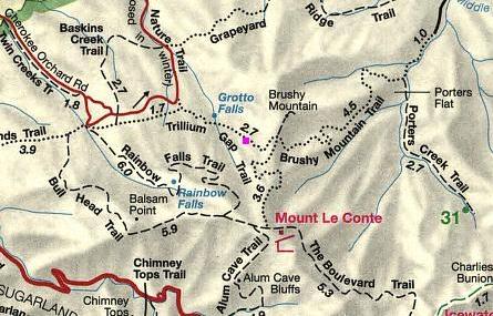
Mount LeConte (via Trillium Gap) Trail Highlights
- Trail Features
Panoramic Views, Waterfalls
- Trail Location
Roaring Fork Motor Nature Trail
- Roundtrip Length
13.9 Miles
- Elevation Gain (total)
3401 Feet
- Elevation Gain (per mile)
489 Feet
- Trail Difficulty
20.70
Strenuous
This strenuous hike is 13.9 miles roundtrip and includes 3401 feet of elevation gain.
Mount LeConte (via Trillium Gap) Description
To reach Mount LeConte on this route you'll follow the Trillium Gap Trail for almost the entire length of your hike. The first section of trail is technically an access trail. At 0.15 miles you'll link up with the Trillium Gap Trail. Hikers should proceed straight ahead at this junction.
The first segment of the Trillium Gap Trail meanders through a beautiful old-growth forest, which includes many large hemlocks. If you have the opportunity to hike this trail during the spring you'll likely witness a smorgasbord of wildflowers along the route, including white and yellow trillium, white violets, stitchwort, squawcorn and Dutchman's breeches, which are common in this area.
For the most part the trail to Grotto Falls, your first destination along this route, travels a gentle grade along a wide and well-worn path.
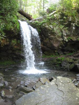
At 1.3 miles hikers will reach Grotto Falls, the only waterfall in the park that a person can actually walk behind. The 25-foot high waterfall offers a cool, shady and moist retreat for summer hikers. Similar to the Rainbow Falls Trail, the trail to Grotto Falls can be quite busy during peak seasons, however, beyond the falls, the crowds thin considerably.
As you walk behind the falls you'll not only hear, but also feel the thunderous power of the water plunging into the pool in front of you. Watch your footing as you pass through here - especially in the winter - as the area surrounding the falls is perpetually wet and slick. To continue on towards Mount LeConte hikers should proceed around the falls.
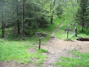
At just over 3 miles you'll arrive at Trillium Gap and the junction with the Brushy Mountain Trail (see photo below). A turn to the left and a short hike of roughly one-third of a mile will lead you to the summit of Brushy Mountain, a point that offers outstanding views of Mount LeConte and the entire eastern flank of the Smoky Mountains. Continuing straight ahead at this junction will lead you down to the Greenbrier area via the Brushy Mountain Trail. To proceed towards the summit of Mount LeConte, hikers should turn right at this junction.
Don't be surprised if you run into a pack train of llamas along the stretch between Trillium Gap and the summit. This section of trail is traveled three times a week by llama trains as they transport supplies to the LeConte Lodge.
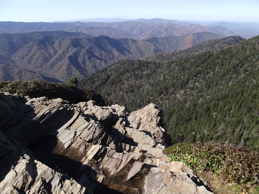
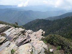
At roughly 6.6 miles the trail dead-ends into the Rainbow Falls Trail. Just prior to reaching the junction you will have passed the LeConte Lodge on your right. For many people the lodge marks the end of the trail; however, to reach the actual summit of Mt. LeConte you'll still have to walk another three-tenths of a mile. Hikers should turn left at this junction to visit the summit. If you simply wish to take-in some panoramic views, your best option is to turn right at this junction and head towards the LeConte Lodge area. After walking a very short distance you'll reach a short side trail on your right that leads down to the main lodge. A turn to the left at this junction will lead you to Cliff Top where you'll enjoy outstanding views of the western Smokies, located roughly two-tenths of a mile further up the mountain (see photo below).
The summit, better known as High Top, is at the 6.9-mile mark. You'll know you've reached the highest point on the mountain when you reach the large cairn just off the main trail on your right.
At 6593 feet, Mount LeConte is the third highest peak in the Smokies. However, measured from its immediate base to its highest point, Mt. LeConte can be considered the tallest mountain in the Eastern United States, rising 5301 feet from its base near Gatlinburg.
There is considerable controversy over which member of the LeConte family the mountain was named for. Most people, including the USGS, assume that Joseph LeConte, the famous geologist and charter member of the Sierra Club, is who the mountain was named for. However, that claim has been challenged in recent years. The authors of A Natural History of Mount Le Conte, and the Georgia Encyclopedia, both claim the name honors Joseph's older brother, John, who was famous as a scientist and as president of the University of California, at Berkeley.
Unfortunately you won't have any vistas from High Top. However, there are two places on the mountain that do afford outstanding panoramic views. One is at Myrtle Point.
To reach Myrtle Point you'll have to walk another 0.4 miles by continuing along the main path, which has now turned into the Boulevard Trail. Roughly 0.2 miles from High Top you'll reach a spur trail on the right side of the trail. After turning onto the spur, walk another 0.2 miles to reach Myrtle Point. This vantage point provides nearly 360-degree views, and is the best location for sunrises on Mt. LeConte.
The other place to visit for outstanding views is Cliff Top, which is located near the LeConte Lodge. You will have passed two side trails that lead to Cliff Top, on your right, as you made your way up to High Top. Cliff Top is the best location for sunsets.
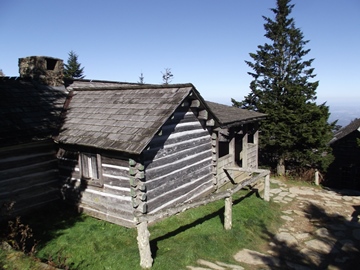
One of the unique aspects about the hike to Mt. LeConte is the lodge and overnight cabins near the top of the mountain. Hikers will have the option of spending the night in one of the historic cabins on the site, which in total can accommodate up to 50 guests a night (you'll need to make reservations well in advance). For more information you can visit the LeConte Lodge website. Hikers may also want to note that the lodge now offers beverages, baked goods and sack lunches to day hikers.
The idea for the lodge came about when Paul Adams, an enthusiastic hiker and explorer, led an expedition up the mountain with some dignitaries from Washington to show them the rugged beauty of the Great Smoky Mountains, and to help promote the cause for national park status. The group spent the night in a large tent. The following year Adams would build a cabin on that same spot, which eventually led to the establishment of the LeConte Lodge. Adams is also credited with helping to blaze the trail from Alum Cave to the summit of Mount LeConte.
In 2011 the Trillium Gap Trail itself achieved a bit of fame. On July 6th of that year, Ashrita Furman became the first person to climb Mt. LeConte on stilts, and in the process, set the Guinness Book of World Records for the highest vertical height walked on stilts. Using peg stilts made of rubber tubing that were 40.5 inches in total height, and 18 inches from the ground to his ankle, Mr. Furman made the 4018-foot climb in 3 hours and 45 minutes. Mr. Furman also holds the record for holding the most Guinness World Records.
Hikers should note that the Roaring Fork Motor Nature Trail is closed during the winter (from December through mid-March). However, you can still reach Mt. LeConte via Trillium Gap by starting your hike from the Rainbow Falls Trailhead, located off Cherokee Orchard Loop Road. This, however, will add another 3.4 miles to your overall roundtrip hike.
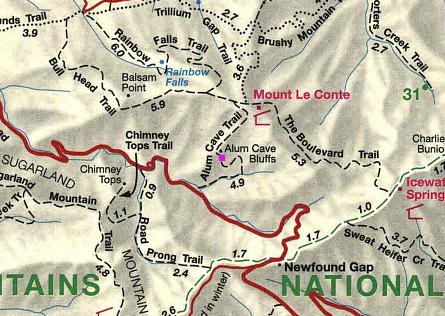
Mount LeConte (via Trillium Gap) Map

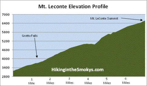
Mount LeConte (via Trillium Gap) Elevation Profile
Directions to Trailhead:
This hike to Mt. LeConte in the Smoky Mountains begins from the Trillium Gap Trailhead, located just outside of Gatlinburg. Starting from Light 8 in Gatlinburg turn onto Historic Nature Trail / Airport Road. After driving 0.7 miles veer right onto Cherokee Orchard Road, upon which you'll enter into Great Smoky Mountain National Park. After driving another 2.2 miles you'll enter the one-way Cherokee Orchard Loop Road. Drive another 0.9 miles on the loop before turning right onto the Roaring Fork Motor Nature Trail. The parking area for the Trillium Gap Trail will be on the left side of the road after driving roughly 1.6 miles along this one-way road. The trailhead is located just beyond the parking area on the opposite side of the road. Due to the popularity of this trail, there are additional parking spaces further up the road. Your best bet is to arrive early during the peak visitor season.