Indian Creek Falls Highlights
- Trail Features
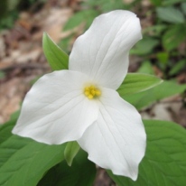
Waterfalls, Wildflowers
- Trail Location
Deep Creek
- Roundtrip Length
1.9 Miles
- Elevation Gain (total)
150 Feet
- Elevation Gain (per mile)
158 Feet
- Trail Difficulty
2.20
Easy
This easy hike is 1.9 miles roundtrip and includes 150 feet of elevation gain.
Indian Creek Falls Description
Indian Creek Falls is accessed via the Deep Creek Trail, which was one of the first trails constructed by the Civilian Conservation Corps in the newly legislated park in the early 1930s. The current Deep Creek Campground also served as the site for the Deep Creek CCC Camp from 1933 to 1936.
In 1910 Horace Kephart, author of Our Southern Highlanders, lived for a short time with the Bob Barnett family in one of the last houses located along the upper portions of Deep Creek. Until his death, as a result of an auto accident in 1931, Kephart also used the old Bryson Place as his summertime camping spot. A permanent historical marker near Backcountry Campsite 57, located just north of the junction between the Deep Creek Trail and Martins Gap Trail, now commemorates the site.
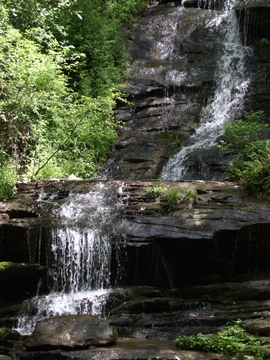
The trail begins as a wide path as it traces Deep Creek upstream. Rewards are almost immediate on this hike. Only three-tenths of a mile from the trailhead the 80-foot Toms Branch Falls (photo on the right) spills down into the creek from the opposite bank. The National Park Service has provided several wooden benches for admiring this beautiful waterfall.
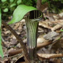
Wildflowers are also quite abundant along this trail. As you proceed towards Indian Creek Falls you'll find a variety of trilliums, blooming at different times throughout the spring, as well as foamflower, galax, crested dwarf iris, beard tongue, Solomon's seal, cinquefoil, bloodroot, bluets and blue-eyed grass. Jack-in-the-pulpit is also abundant, but is sometimes hard to locate among the wild geranium, clinton's lily and the large houstonia.
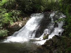
To reach Indian Creek Falls, continue beyond Toms Branch Falls for another half-mile, and then turn right onto Indian Creek Trail. After walking just one-tenth of a mile there will be a short spur trail on your left that leads down to the 45-foot waterfall. If you were to climb back to the main trail and walk a short distance up the trail, you'll notice that Indian Creek Falls is actually more of a water slide than a true waterfall.
If you're looking for additional hiking opportunities in this area, you will have the option of continuing along this same trail to access the Deep Creek Loop trail, which would add another 2.4 miles to your total roundtrip mileage.
As another option, if you wish to visit another waterfall, Juney Whank Falls is also located in this area, and can be reached via a short half-mile hike from the same parking lot.
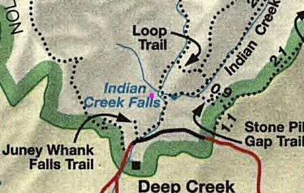
Indian Creek Falls Map
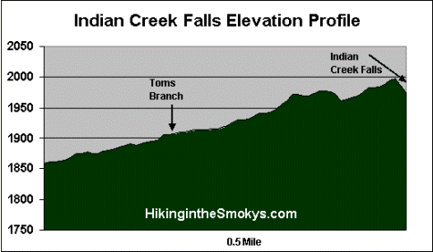
Indian Creek Falls Elevation Profile
Directions to Trailhead:
The hike to Indian Creek Falls in the Great Smoky Mountains begins from the Deep Creek Trailhead, located just north of Bryson City, North Carolina. To reach the trailhead from the intersection of Rt. 441 and Rt. 19 in Cherokee, drive 10 miles south on Route 19 to Everett Street in Bryson City. Turn right onto Everett and drive for 0.2 miles, and then turn right onto Depot Street. After a short distance turn left onto Ramseur Street, and then make an immediate right onto Deep Creek Road. Drive another 2.3 miles to the park entrance, and then from there another half-mile to the parking area for the Deep Creek Trailhead.