Huskey Gap (via Newfound Gap Road) Highlights
- Trail Features
Quiet Forest Hike, Wildflowers
- Trail Location
Newfound Gap Road
- Roundtrip Length
4.2 Miles
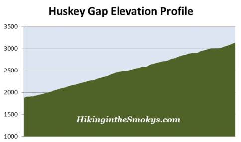
- Elevation Gain (total)
1270 Feet
- Elevation Gain (per mile)
605 Feet
- Trail Difficulty
6.74
Moderately Difficult
This moderately difficult hike is 4.2 miles roundtrip and includes 1270 feet of elevation gain.
Huskey Gap (via Newfound Gap Road) Description
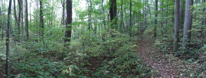
From the trailhead the Huskey Gap Trail climbs gently away from Newfound Gap Road. After several minutes of walking through a second growth forest the noise from automobile traffic quickly fades away, and you'll begin to feel like you're hiking in the wilderness.
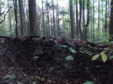
After walking a little more than a tenth-of-a-mile, look down hill from the trail, on your right, and you'll notice the remains of an old stone fence from one of the old homesteads in this area. You may also notice some fairly large tulip trees in this area as well.
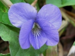
The Huskey Gap Trail is usually one of the trails included on the hiking schedule of the Great Smoky Mountains Association's Annual Spring Wildflower Pilgrimage Tour (held in April), which means this is a great hike if you're looking to spot a wide variety of wildflowers.
Some of the wildflowers that can be found during the spring include Canadian Violets, False Solomon's Seal, Yellow Trillium, Purple Phacelia, Crested Dwarf Iris, Star Chickweed, Sweet White Violet, Wild Geranium, May Apple, Cutleaf Toothwort, Common Blue Violet, Rue Anemone, Sweet Shrub, Dog Hobble, Dogwood, Trillium Erect, Wild Ginger, Yellow Mandarin, Bishop Caps, Foam Flower, Blue Cohosh, Squirrel Corn, Silver Bell, Squaw Root, Halberd Leaf Violet and Cinquefoil.
At roughly 1.1 miles, as you ascend one of the lower flanks along Sugarland Mountain, the trail crosses over a small stream known as Flint Rock Branch.
At 2.1 miles hikers will arrive at the Sugarland Mountain Trail junction at Huskey Gap. You won't have much of a view here; however, if you continue along the Huskey Gap Trail for a short distance beyond the junction you'll have a few peeks into the mountains towards the west.
On your return trip, look due east for glimpses of Mount LeConte through the trees.
The trail receives its name from Sam Huskey, who once owned a homestead near the gap around the turn of the 20th century. In the late 19th century the residents in the small communities of Little River (now known as Elkmont) and the Sugarlands, built a log schoolhouse at Huskey Gap. They also constructed a crude road that eventually became the Huskey Gap Trail.
If you're in a group with multiple vehicles you could create a one-way hike by heading 3 miles north along the Sugarland Mountain Trail, towards Fighting Creek Gap near Laurel Falls. You could also continue heading west on the Huskey Gap Trail towards the Little River Trail, and then proceed north to the parking area at Elkmont, which is located roughly 5 miles from the junction.
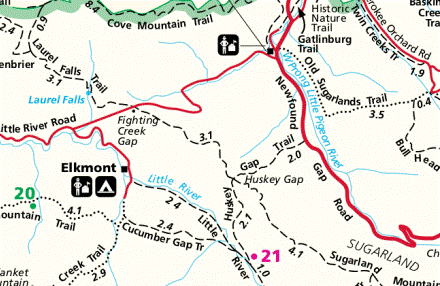
Huskey Gap (via Newfound Gap Road) Map
Huskey Gap (via Newfound Gap Road) Elevation Profile
Directions to Trailhead:
From the Sugarlands Visitor Center near Gatlinburg, drive 1.6 miles south along Newfound Gap Road to reach the Huskey Gap Trailhead. The parking lot for the Huskey Gap Trail will be on your left, while the trailhead is located across the street. The parking lot has room for only 6 vehicles.