Gregory Bald (via Gregory Ridge Trail) Highlights
- Trail Features
Panoramic Views, Flame Azaleas
- Trail Location
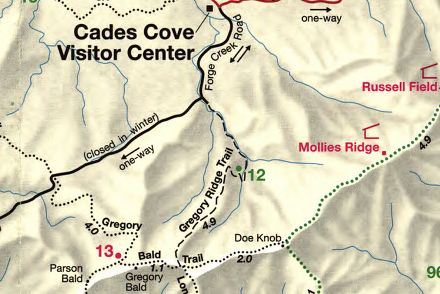
Cades Cove (Forge Creek Road)
- Roundtrip Length
11.3 Miles
- Elevation Gain (total)
3020 Feet
- Elevation Gain (per mile)
535 Feet
- Trail Difficulty
17.34
Strenuous
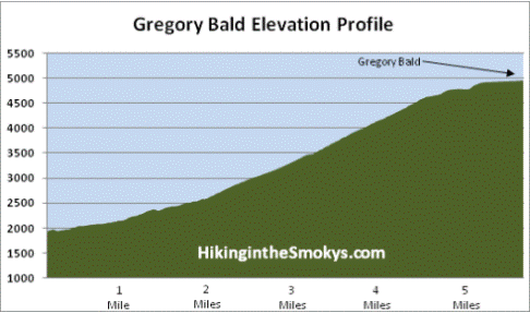
This strenuous hike is 11.3 miles roundtrip and includes 3020 feet of elevation gain.
Gregory Bald (via Gregory Ridge Trail) Description
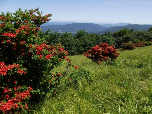
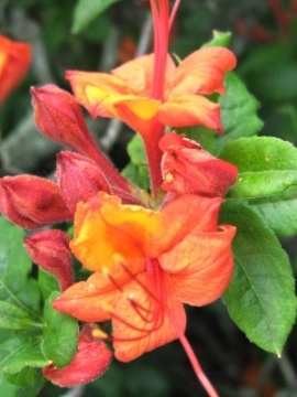
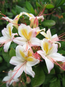
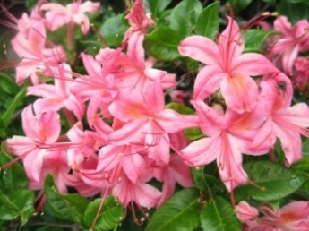
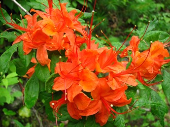
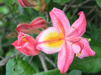
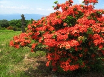
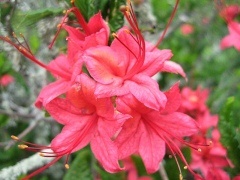
As stunning as the year-round views are, Gregory Bald is perhaps most famous for the spectacular flame azaleas that bloom atop its summit each summer. Azalea lovers from all over the world come here to witness the many acres of fire red, wine red, orange, salmon, yellow, white, pink, and multi-colored azaleas that reach peak bloom around mid-to-late June.
According to the Great Smoky Mountains Natural History Association, the various hybrids of azaleas on Gregory Bald are so impressive and unique that the British Museum of Natural History has collected numerous samples of them. Flame azaleas were originally discovered by pioneer naturalist William Bartram while exploring the Cherokee country in 1776. He called them "fiery Azalea", and described them as "certainly the most gay and brilliant flowering shrub yet known".
The flame azaleas atop Gregory Bald also played an important role in the creation of a national park in the Smokies. In an interview for a report on the historical uses of grassy balds in the Great Smoky Mountains, Carlos Campbell, a founding member of the Smoky Mountains Hiking Club and the secretary of the Great Smoky Mountains Conservation Association, noted that at least one dignitary from Washington DC was quite impressed with the azaleas atop Gregory Bald. While investigating the southern Appalachians for a possible national park location, members of a national committee were sent to the Smokies in 1924. During the visit the association took two committee members to Mt. LeConte and Gregory Bald. One of those members was Harlan P. Kelsey, a renowned botanist. In the interview Campbell noted that "Mr. Kelsey made the statement that the flame azalea, which, incidentally, was one of his favorite shrubs, reached its maximum development anywhere in the country on and near Gregory Bald and said that was one of the highlights, one of the things that made this area worthy of being a National Park."
Although this isn't an easy place to get to, there were still at least 60 or 70 people atop the sprawling summit when we arrived. Normally when you reach a hiking destination that requires a fairly tough hike, people are usually taking in the scenery, eating a picnic lunch, or just relaxing. On this particular day, however, you could describe the mood as festive. People were practically giddy at the riot of colors all around. There was even one group that sang "the hills are alive with the sound of music", as they were getting ready to head back down the mountain. It's completely understandable that the azaleas and the views here would have this affect on people - this place is truly special. In fact, I would go so far as to say that this should be on the life list of any self-respecting hiker, gardener, or nature lover.
To reach Gregory Bald we began our hike from the Gregory Ridge Trailhead. Yes, the Gregory Bald Trail is a shorter hike to the summit, but you're committed to driving the one-way Parson Branch Road which eventually takes you to the southwest corner of the park. Personally I'd rather hike the additional mile each way than drive a couple of hours to get back to Townsend.
Along the lower sections of the trail hikers will cross three footbridges before reaching Backcountry Campsite 12, located roughly two miles from the trailhead.
At roughly 2.4 miles you'll enter a stretch of trail where a forest fire had swept through a few years ago. Coincidentally, a campfire was still smoldering in the fire ring at the campsite we just passed - with no campers in sight.
After passing the campsite the trail begins a relentless climb of roughly 2000 feet over the next 3 miles.
At 4.9 miles you'll reach the Gregory Bald Trail junction. After turning right here the trail begins a sharp climb over the next one hundred yards or so. It then flattens out for a while before making one last push to the summit.
Gregory Bald is a 10-acre grassy meadow, and is one of two balds maintained by the park. It's not clear whether this high elevation meadow was created by nature, or was cleared by some of the early settlers. Without periodic maintenance from the National Park Service, both Andrews Bald and Gregory Bald would be reclaimed by natural forest growth.
The Bald is named after Russell Gregory, an early homesteader in the Cades Cove area. He and other cove residents used the meadow to graze cattle during the spring and summer when cove fields were used for growing crops. Like most cove residents Gregory supported the Union during the Civil War, but he was ambushed and murdered by Confederate guerillas from North Carolina in 1863.
Russell Field, a couple miles towards the east, is likely named after Mr. Gregory as well.
At one point the Appalachian Trail crossed Gregory Bald before exiting the park at Deals Gap. On the Library of Congress's website you'll see the first park map issued to the public in 1940, as well as the revised 1941 map, both showing the AT crossing Gregory Bald. However, after Fontana Dam was built, the AT was re-routed to cross over the new dam. My new book on the history of hiking has much more information about trail development in the Smokies, as well as other anecdotal stories from the early years of the park.
On a clear day hikers will be able to see Cades Cove and Rich Mountain towards the north, Fontana Lake towards the southeast, and Thunderhead Mountain and Clingmans Dome towards the east.
If you can't make it in June, another great time to visit Gregory Bald is in August when the wild blueberries are ripening at the summit. Keep in mind though that bears love blueberries as well, so you'll want to be a little more cautious during this time period. The outstanding views from the summit makes anytime throughout the year a great time to visit Gregory Bald. In fact, this hike ranks as number one on my list of the Best Hikes in Great Smoky Mountains National Park
Gregory Bald (via Gregory Ridge Trail) Map
Gregory Bald (via Gregory Ridge Trail) Elevation Profile
Directions to Trailhead:
This hike to Gregory Bald in the Great Smoky Mountains begins from the Gregory Ridge Trailhead in Cades Cove. To reach the trailhead from the Townsend "Y" intersection, travel west on Laurel Creek Road towards Cades Cove. After driving 7.5 miles you'll reach Cades Cove, pass the main parking lot, and then enter the one-way loop road. Roughly 13.2 miles from Townsend the loop road makes a sharp turn to the left. At this junction continue by driving straight onto Forge Creek Road (which also leads to Parson Branch Road). Drive for another 2.2 miles to reach the Gregory Ridge Trailhead. Just before reaching the parking lot the one-way Parson Branch Road forks off to the right. You should continue on the two-way Forge Creek Road for a short distance to reach the Gregory Ridge Trail parking area.
Hikers should note that the park closes the Cades Cove Loop Road to motor vehicle traffic on Wednesday and Saturday mornings until 10:00 a.m., between early May and late September of each year, to allow cyclists and pedestrians to enjoy the cove.