Cove Mountain Highlights
- Trail Features
Waterfalls, Old Growth Forest
- Trail Location
Little River Road
- Roundtrip Length
7.7 Miles
- Elevation Gain (total)
1776 Feet
- Elevation Gain (per mile)
461 Feet
- Trail Difficulty
11.25
Strenuous
This strenuous hike is 7.7 miles roundtrip and includes 4139 feet of elevation gain.
Cove Mountain Description
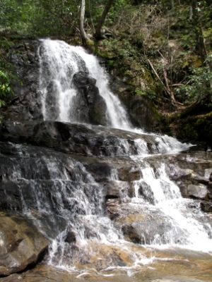
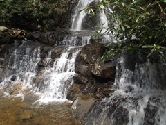
With Laurel Falls being only a little more than a mile from the road, this trail is one of the most popular destinations in the park. Finding parking during peak season can be a problem. If you're looking to avoid the crowds your best bet is to begin your hike early in the morning, during the early evening, on a weekday, or during the off-season.
The Laurel Falls Trail was built in 1932 to provide fire crews with access to the Cove Mountain area in the event of a forest fire. By the early 1960s, however, Laurel Falls had become a popular hiking destination for visitors, and major erosion was beginning to take a toll on the trail. As part of the 1963 Accelerated Works Projects grant to the Department of Interior, the Laurel Falls Trail was paved in order to halt problems with erosion.
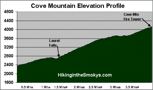
In just over 1.1 miles, and a climb of about 315 feet, hikers will arrive at the 80-foot falls. If you've never had the opportunity to see this beautiful waterfall you'll immediately discover why this trail is so popular.
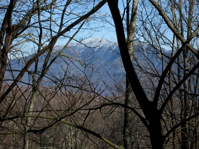
After leaving the pavement, and the crowds, the trail ascends through a canopy of rhododendron over the next half-mile or so. As you walk through this section of trail the hum of Laurel Branch Creek can be heard cascading down the valley on your right. From time to time you'll have some decent views of the mountains to the south. Further up the trail you'll be able to catch a glimpse of Mount LeConte towards the southeast. Most of these views, however, will be obstructed once the summer foliage arrives.
The trail above Laurel Falls travels through an old growth forest, so you'll likely notice some very large trees along this stretch of the trail.
At 2.8 miles the Little Greenbrier Trail branches off to the left. Hikers should proceed straight ahead at this junction to continue towards the summit of Cove Mountain.
At 3.7 miles the Laurel Falls Trail dead ends into the Cove Mountain Trail. Hikers should turn left here and walk for another tenth-of-a-mile to reach the old fire tower that sits atop the summit of Cove Mountain. The 60-foot tower, built in 1935, and one of only four towers remaining in Great Smoky Mountains National Park, is no longer used for monitoring forest fire threats. Instead, the National Park Service has transformed it into an air quality monitoring station. As a result, hikers aren't allowed access to the tower.
Although there isn't much of a view at the summit, the trail is still a very pleasant hike.
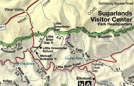
Cove Mountain Map
Cove Mountain Elevation Profile
Directions to Trailhead:
The hike to Cove Mountain in the Great Smoky Mountains begins from Laurel Falls Trailhead at Fighting Creek Gap. To reach the trailhead from the Sugarlands Visitor Center near Gatlinburg, drive 3.8 miles to the top of Fighting Creek Gap. The parking area for the Laurel Falls Trailhead will be on your right.
From the Townsend "Y" intersection near Cades Cove, the Laurel Falls / Cove Mountain trailhead is located 13.7 miles away.