Chasteen Creek Cascade Highlights
- Trail Features
Waterfall, Stream, Wildflowers
- Trail Location
Smokemont Campground
- Roundtrip Length
3.6 Miles
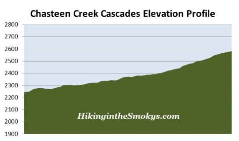
- Elevation Gain (total)
340 Feet
- Elevation Gain (per mile)
189 Feet
- Trail Difficulty
4.28
Easy
This easy hike is 3.6 miles roundtrip and includes 340 feet of elevation gain.
Chasteen Creek Cascade Description
The hike to Chasteen Creek Cascade begins from the Smokemont Campground on the North Carolina side of the Smokies. Smokemont was originally the base camp for the Champion Fibre Company. As a thriving lumber town it housed a logging mill, commissary, a club house, homes, businesses, a school, and even a hotel. In the early 1920s the Smokemont sawmill produced up to 45,000 feet of lumber and pulp wood per day.
The hike begins by following the Bradley Fork Trail. This hike also follows the Benton MacKaye Trail, a footpath that stretches nearly 300 miles through the Southern Appalachian Mountains, including 96 miles through the Great Smoky Mountains. The trail was designed in the tradition of the Appalachian Trail, which was the brainchild of Benton MacKaye, a forester and co-founder of The Wilderness Society.
In a little over a tenth-of-a-mile hikers will pass a campground trail that connects the Bradley Fork Trail to the parking area near the Smokemont Baptist Church, located near the entrance to the campground.
A little further up the trail, about a quarter-of-a-mile from the trailhead, the Tow String Horse Trail forks in from the right. From this point forward you'll be sharing the trail with horses.
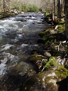
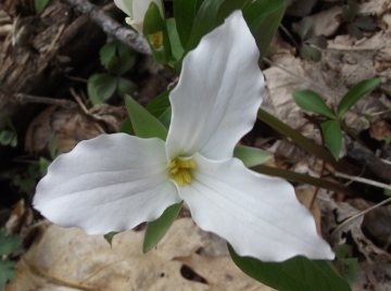
The Bradley Fork Trail is actually an old road bed that parallels the Bradley Fork of the Oconaluftee River. Much of the creek is quite scenic, with lots of rhododendron, grasses and moss, giving the area a lush green appearance. This is also a great hike for viewing a wide variety of spring wildflowers. During our mid-April hike we saw white trillium, fringed phacelia, foamflower, violets, daffodils, and a few other varieties we couldn't identify.
At roughly 1.1 miles the trail crosses over Chasteen Creek, and shortly thereafter you'll reach the Chasteen Creek Trail. Hikers should take a right at this junction to continue on towards the Chasteen Creek Cascade. Less than 50 yards past the junction the trail passes Backcountry Campsite 50.
Along the Chasteen Creek Trail we saw even more wildflowers, including forsythia, azaleas, and several other varieties we couldn't identify.
At roughly 1.7 miles hikers will arrive at a split in the trail. Just off the left fork you'll notice a horse hitching post and a platform. Take this side trail and continue past the hitching post. Once past the hitching post you'll notice a faint trail that continues leading upstream alongside the creek. After walking a very short distance the cascade will come into view.
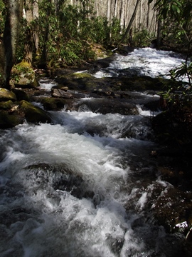
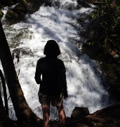
Chasteen Creek Cascade is roughly 30 feet in height, with a couple of smaller cataracts a little further downstream. These are probably best viewed after a period of heavy rain.
Once back on the main trail the Chasteen Creek Trail continues on for another 3.7 miles before dead-ending at the junction with the Hughes Ridge Trail and the Enloe Creek Trail. To return back to the trailhead from this point simply retrace your steps.
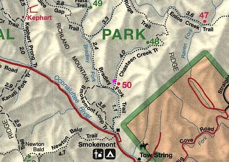
Chasteen Creek Cascade Map
Chasteen Creek Cascade Elevation Profile
Directions to Trailhead:
The hike to Chasteen Creek Cascade in the Great Smoky Mountains begins from the Smokemont Campground, located 3.5 miles north of the Oconaluftee Visitor Center on Newfound Gap Road (or 25.6 miles south of the Sugarlands Visitor Center near Gatlinburg). After turning into the campground area, make a left turn immediately after crossing the Oconaluftee River to continue into the campground. Then drive all the way to the far end of the campground in Section D. The trailhead is located next to the hiker parking lot in Section D. During the winter months, Sections C and D of the campground are closed, so hikers will have to park in the Section B parking area. The walk to the trailhead from this lot is roughly 0.35 miles.