Gatlinburg Trail Highlights
- Trail Features
Stream / History
- Trail Location
Gatlinburg / Sugarlands Visitor Center
- Roundtrip Length
3.9 Miles
- Elevation Gain (total)
235 Feet
- Elevation Gain (per mile)
121 Feet
- Trail Difficulty
4.37
Easy
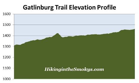
This easy hike is 3.9 miles roundtrip and includes 235 feet of elevation gain.

Gatlinburg Trail Description
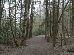
From the edge of town the wide footpath almost immediately begins to follow the West Prong of the Little Pigeon River. Along much of this route you'll have easy access to the river if you wish to dip your toes into the water. Much of this route also follows along US 441 (Newfound Gap Road), which means you can expect a fair amount of noise in some areas. At just over one-half mile the trail crosses over the river along one of the longest footbridges in the park:
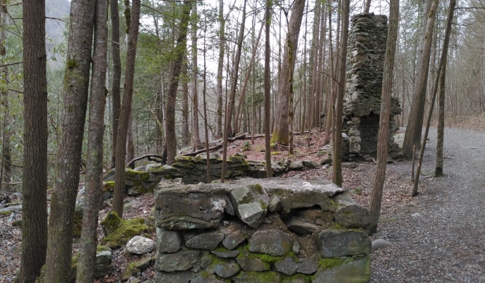
Shortly after crossing the river the trail begins a short climb. After reaching the top of the hill the trail passes the remnants of an old homestead, which includes a chimney and a few other rock structures:
From the homestead the trail makes a quick descent, and soon passes beneath the Gatlinburg Bypass. This spot roughly marks the halfway point on this trail. During this stretch you may begin to notice a few small burn scars, remnants and reminders of the 2016 wildfire that devastated the Gatlinburg area. On November 23, 2016 two juveniles started a wildfire near the Chimney Tops summit. By November 28th the fire grew to 500 acres. After several months of exceptional drought conditions, and winds gusts reaching more than 80 mph that afternoon, the fire literally exploded. Over the next several hours it burned almost 18,000 acres, including 11,410 acres within Great Smoky Mountains National Park. From Chimney Tops the fire raced north, passing around the edges of downtown Gatlinburg and reaching the outskirts of Pigeon Forge. Before it was brought under control the fire killed 14 people, injured more than 176 people, and damaged or destroyed at least 2460 structures at a cost of more than $500 million.
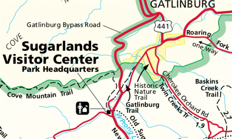
At roughly 1.2 miles the trail begins passing a series of park maintenance buildings. Once past this district the path begins to follow the Park Headquarters Road. Eventually the trail completely disappears, and you'll begin walking along the road itself. At roughly 1.8 miles you'll see a sign indicating the Gatlinburg Trail continues towards the visitor center. From this point you'll follow a sidewalk to reach the visitor center. Along this stretch it will pass the historic park headquarters building. Just before reaching the Sugarlands Visitor Center, at roughly 1.9 miles from Gatlinburg, you'll reach a side trail that leads to Cataract Falls. This waterfall is roughly one-half mile away if you wish to see it. From this junction the visitor center is only a short walk away. If you wish to begin your hike from the Sugarlands Visitor Center, the GPS coordinates for this trailhead are 35.68579 -83.53677.
Hikers may want to note that the Gatlinburg Trail is one of two trails in the park that allow visitors to walk dogs (on leashes only) and ride bicycles. The Oconaluftee River Trail near Cherokee is the other.
Gatlinburg Trail Map
Gatlinburg Trail Elevation Profile
Directions to Trailhead:
The hike along the Gatlinburg Trail in the Great Smoky Mountains begins from either Gatlinburg or the Sugarlands Visitor Center. This hike description follows the trail for those wishing to start their hike in Gatlinburg. This trailhead is located near Light 10 at the edge of town, on the border of the national park. There are a couple of small parking areas along River Road that offer free parking. There's also a large paid parking lot near the corner of US 441 and Ski Mountain Road. If you prefer, you can also begin your hike from the Sugarlands Visitor Center, and then use this guide in reverse.