Russell Field - Spence Field Loop Highlights
- Trail Features
Panoramic Views, Mountain Laurel
- Trail Location
Cades Cove Picnic Area
- Roundtrip Length
13.3 Miles
- Elevation Gain (total)
3050 Feet
- Elevation Gain (per mile)
459 Feet
- Trail Difficulty
19.40
Strenuous
This strenuous hike is 13.3 miles roundtrip and includes 3050 feet of elevation gain.
Russell Field - Spence Field Loop Description
The Anthony Creek Trail starts off by following Abrams Creek out of Cades Cove. At just three-tenths of a mile from the trailhead hikers will pass the Crib Gap Trail junction, and then shortly thereafter, the Anthony Creek Horse Camp. At this point you may have already noticed some of the "clues" left on the ground indicating that this trail also functions as a horse path.
We last hiked this trail in mid-June when the rhododendron were just beginning to bloom along the lower sections of the trail.
At just over 1.7 miles you'll reach the Russell Field Trail junction. Hikers should turn right here to begin the loop portion of the hike. Almost immediately this new path begins climbing steeply towards the crest of the Smokies. At roughly 3.5 miles the trail makes a sharp turn to the left, and then levels out for the next three-quarters of a mile as it traverses along the top of Leadbetter Ridge.
At roughly 4.75 miles, just after the trail makes another sharp turn to the left, look for a couple of short side trails branching off towards the left. These short "social" trails lead to a small meadow, the remnants of Russell Field before the National Park Service allowed the larger portions to be reclaimed by forest.
Russell Field is likely named after Russell Gregory, an early settler in the Cades Cove area. He and/or other cove residents used the field to graze sheep and cattle during the spring and summer when the fields in the cove were needed for growing crops. Like most Cades Cove residents, Gregory supported the Union during the Civil War. He was killed by Confederate guerillas from North Carolina in an ambush in 1863.
Gregory Bald, a couple miles to the west of this location, is also named after Mr. Gregory.
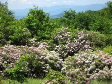
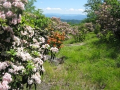
At roughly 5.2 miles from the trailhead hikers will finally arrive at the Russell Field Shelter, located near the Appalachian Trail junction. To complete the loop you should turn left onto the Appalachian Trail. During the late spring / early summer time period hikers will enjoy several fine displays of mountain laurel in this area.
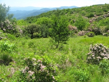
This next section of the loop consists of a three-mile walk along the Appalachian Trail towards Spence Field. As you proceed towards the Bote Mountain Trail junction the Appalachian Trail will pass through a series of small grassy meadows. These are pleasant meadows, but nothing compared to what you'll find at Spence Field on the eastern side of the Bote Mountain Trail junction. Before reaching the western end of Spence Field you'll pass the Eagle Creek Trail junction at 8.1 miles, and shortly thereafter, the Bote Mountain Trail. You'll only have to walk another 100 yards or so beyond this junction to find a great spot to enjoy a picnic lunch, or to simply soak in the grand scenery.
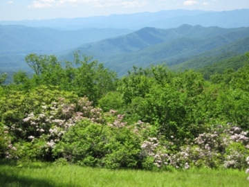
If visibility is good during your visit atop Spence Field you'll have some absolutely outstanding views of the North Carolina side of the Smokies. And if you're there in June you'll witness one of the most spectacular displays of mountain laurel found just about anywhere. The hillsides and meadows will literally be covered in the soft pink and white flowers from this heath family shrub.
Spence Field is named after James Spence, who built a cabin in this area in 1830. The History of the Grassy Balds in Great Smoky Mountains National Park, an online book that can be found on the park website, states that neither Russell or Spence Field are natural grassy balds, but were actually cleared by settlers for the purposes of grazing sheep and cattle.
If you still have the energy at this point you could continue walking eastward along the Appalachian Trail for another 1.2 miles to reach Rocky Top. Although you'll have to climb another 550 feet, the views from this vantage point might be some of the best in the park.
If you've decided you're ready to turn around you'll have to backtrack to the Bote Mountain Trail junction. Hikers should turn right here and begin heading back down the mountain.
As you descend you'll walk through a long stretch of trail where rhododendron has formed a tunnel over the Bote Mountain Trail. You'll also notice that the trail has sunk several feet below the ground on either side of the trail. My guess is that this is a result of a combination of erosion, and the trampling of the sheep and cattle that were driven to and from Spence Field prior to the establishment of the park.
At roughly 9.8 miles into your hike you'll reach the Anthony Creek Trail. Hikers should turn left here, and then hike 3.5 miles down the Anthony Creek Trail to return back to the trailhead at Cades Cove.
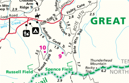
Russell Field - Spence Field Loop Map
Russell Field - Spence Field Loop Elevation Profile

Directions to Trailhead:
The Russell Field - Spence Field loop hike begins from the Anthony Creek Trailhead, located in the Cades Cove picnic area. To reach the trailhead from the Townsend "Y" intersection, drive 7.5 miles west on Laurel Creek Road to the turn-off for the Cades Cove Campground. Turn left towards the campground, and then almost immediately you'll make another left turn towards the picnic area. The Anthony Creek Trailhead is located at the far end of the picnic area.