Big Creek / Mouse Creek Falls Highlights
- Trail Features
Waterfalls
- Trail Location
Big Creek
- Roundtrip Length
4.2 Miles
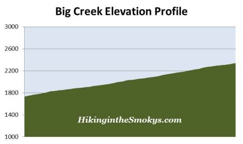
- Elevation Gain (total)
605 Feet
- Elevation Gain (per mile)
288 Feet
- Trail Difficulty
5.41
Moderately Difficult
This moderately difficult hike is 4.2 miles roundtrip and includes 605 feet of elevation gain.

Big Creek / Mouse Creek Falls Description
The Big Creek Trail follows an old railroad grade, built by the Crestmont Lumber Company in the early 1900's to haul lumber out of the mountains during the logging boom. The trail was improved by the Civilian Conservation Corp in the early 1930s when it was converted for hiking use.
With a relatively smooth and even surface that climbs gradually over the course of its 2.1 miles to Mouse Creek Falls, this is an outstanding hike for young or novice hikers.
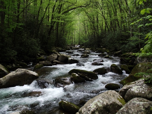
At first the wide path climbs high above the Big Creek Campground, and away from the creek. After roughly 1.3 miles, however, the trail finally makes contact with the creek, and for the rest of this hike you'll never leave the sight or sounds of Big Creek. Wildflowers and rhododendron also line the pathway throughout this section of trail.
As you proceed higher you may notice a boulder field off to the right of the trail. This is just one of the after-effects from the logging days. The erosion caused by stripping the mountainside of trees has exposed these underlying boulders. Unfortunately, logging has left many permanent scars like this throughout the Smokies.
The scale of logging operations in the Big Creek area was fairly significant. During its peak the mill at Crestmont was able to process up to eighty-thousand board feet a day. However, in the 1930s, when the Great Smoky Mountains Park Commission began purchasing property for the new national park, the lumber company sold its 20,229-acre Big Creek tract to the park for $5.50 per acre.
At roughly 1.5 miles the trail passes Midnight Hole, a deep, emerald green pool that lies just below a six-foot waterfall flowing between two large boulders. If you're lucky you may see a trout scooting through the water here. Unfortunately this spot isn't marked by a trail sign. Moreover, you'll pass a couple of smaller waterfalls along the way that might lead some to believe that they've already reached Midnight Hole. On the flip side you can use this an excuse to take your time to explore the many features along this portion of the trail.
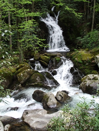
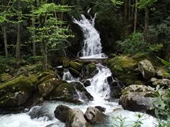
At just over two miles you'll see a hitching post on your left. Continue a little bit further beyond the hitching post and you'll see a short side trail that leads to a viewing area of Mouse Creek Falls. Located on the far side of Big Creek, this 45-foot waterfall emerges from the dense forest to tumble over several tiers of moss covered rocks before crashing into Big Creek. This is an outstanding place to drop your backpack, break out the camera, and grab a snack or picnic lunch.
If you wish to explore more of the terrain in this section of the park you'll have the option of continuing along the Big Creek Trail for another two-tenths of a mile to reach a footbridge spanning Big Creek, which offers great views of pools below and just downstream from the bridge. You can also continue for another 3 miles beyond Mouse Creek Falls, past an old carriage bridge, to visit Walnut Bottom, the site of an old logging camp. Walnut Bottom, now known for its exceptional displays of spring wildflowers, is located just past Backcountry Campsite 37.
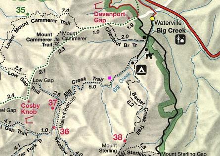
Big Creek / Mouse Creek Falls Map
Big Creek / Mouse Creek Falls Profile
Directions to Trailhead:
The hike to Mouse Creek Falls in the Great Smoky Mountains begins from the Big Creek area. To reach the trailhead from I-40 near the Tennessee-North Carolina border, take the Waterville Road Exit (#451). Turn left after crossing the Pigeon River and proceed 2.1 miles to a 4-way intersection. Continue straight ahead onto the narrow gravel road and drive past the ranger station to a large parking area at the end of the road. The Big Creek Trailhead is located on the right, just before reaching the parking area, roughly 3 miles from the highway.