Middle Prong Trail Highlights
- Trail Features
Waterfalls, History
- Trail Location
Tremont
- Roundtrip Length
8.3 Miles
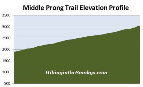
- Elevation Gain (total)
1140 Feet
- Elevation Gain (per mile)
275 Feet
- Trail Difficulty
47.25
Strenuous
This strenuous hike is 8.3 miles roundtrip and includes 1,140 feet of elevation gain.

Middle Prong Trail Description
Hands down the Middle Prong Trail is the best waterfall hike in the Smokies - at least from my perspective. The trail passes three major waterfalls, in addition to numerous smaller falls, cataracts and cascades.
The trail begins at the confluence of the Lynn Camp Prong and the Thunderhead Prong, at the point where the Middle Prong of the Little River officially begins.
Just past the metal footbridge near the trailhead is the former site of a community known as Tremont. In its heyday the lumber camp consisted of a post office, hotel, a general store, maintenance sheds, and a community center that also served as a church, school, and movie theater.
Tremont, a name derived from the combination of "tree" and "mountain," was one of the last areas in the park to be logged. This was the result of Will Walker refusing to sell his property to the Little River Lumber Company. However, after a stroke that left him largely incapacitated, Walker was forced to finally sell his property in 1918. Logging operations would continue in this area until 1938 - four years after the Great Smoky Mountains became a national park. This was permitted as a result of Colonel Wilson B. Townsend selling his Little River tract to the Great Smoky Mountains National Park Commission in 1926, in exchange for an agreement that allowed him to continue logging in the area for another 15 years.
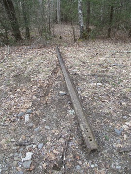
Although it appears to be a gravel road, the Middle Prong Trail was actually a railroad bed that was used by the Little River Lumber Company to haul logs out of area. After logging operations ceased within park boundaries, the Civilian Conservation Corps converted many of the old railroad beds into roads and trails. Evidence of the old Lynn Camp Prong line can be found a couple miles up the trail.
From the trailhead hikers will cross a metal footbridge over Lynn Camp Prong. Over the course of the first couple of miles you should keep an eye out for violets, crested dwarf iris, wood sorrel, rue anemone, foamflower, toothwort and trilliums, if you're hiking in the spring and early summer months.
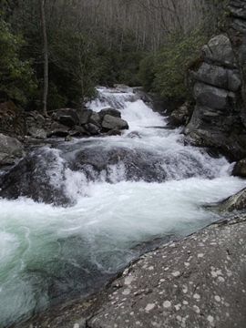
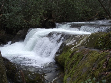
At four-tenths of a mile from the trailhead hikers will reach the Lower Lynn Camp Falls. This 35-foot, multi-tiered waterfall is one of the more impressive falls in the park, especially during the wetter months of the year. Just around the bend, roughly a hundred yards up trail, hikers will have a better view of the upper portions of the falls. With a relatively short, but somewhat difficult bushwhack, you can make it down to the edge of the falls for an up-close view.
Shortly after passing the upper portions of Lower Lynn Camp Falls, look for a small cove that leads to a rocky area on your left. This very short sidetrack provides a view of an impressive cataract hidden from the main trail.
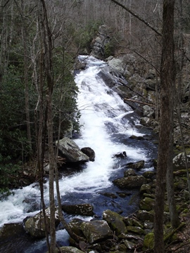
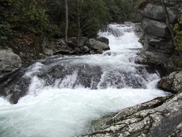
Roughly two-thirds of a mile from the trailhead hikers will reach Lynn Camp Falls, another beautiful, multi-tiered waterfall.
At roughly 1.9 miles you'll reach an old rusting Cadillac lying just off the side of the trail. Although it's not visible from the trail, due to a berm, you may notice a couple of rocks in the middle of the trail, which mark the location of a faint side trail leading off to the right. If you have a GPS the exact location is 35.61286, -83.64413. The Cadillac, presumably a late 1920s / early 1930s model, is roughly 20 yards off the main trail.
Just out of curiosity, I wonder if the National Park views the old car as junk, or as an historical artifact.
At 2.5 miles hikers will reach the Panther Creek Trail, which leads to Jakes Gap.
At the trailhead you may have noticed a small sign that states you won't need hiking boots for this trail. I would have to strongly disagree with that advice. As the trail climbs higher, it gets progressively more rugged in several places.
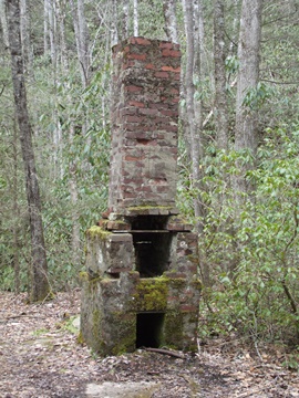
At just over 3.1 miles hikers will pass a chimney from an old homestead on the left side of the trail. Although out in the open, it's easy to miss if you're not paying attention. Roughly 20 yards beyond the chimney will be a fairly large clearing alongside the trail. Look closely and you'll see an old railroad beam lying on the ground. Just beyond the beam, while continuing to look towards your left, are a few other old remnants from the pioneers and logging operations of the past.
At roughly 3.7 miles hikers will cross a footbridge over Indian Flats Prong. Just before reaching this bridge you'll cross two smaller creeks without the benefit of a footbridge. After periods of heavy rain you may want to bring trekking poles to help with your balance as you rock hop across these two streams.
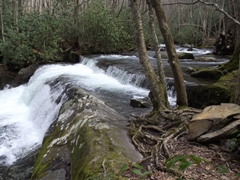
Just above the footbridge, at just over 4 miles from the trailhead, hikers will arrive at an unmarked side trail, which branches off to the right. This trail leads to Indian Flats Falls, your final destination on this hike. Although it's pretty easy to spot, the coordinates for the junction are 35.59345, -83.63212. If you don't have a GPS, the side trail appears near the third switchback above the footbridge.
A hike of less than one-tenth of a mile will lead you to the base of the top tier of Indian Flats Falls. In total, the waterfall drops roughly 60 feet in three separate tiers, with the top tier dropping roughly 20 feet. The middle tier is located near the end of the trail. You'll have to look closely downstream to see the lower tier. Although this is a great spot for a lunch break, you'll want to watch your footing as the rocks are pretty slick in this vicinity. Unfortunately for photographers, the rhododendron and broken terrain in this area makes it very difficult, if not impossible, to get a great view of the lower falls.
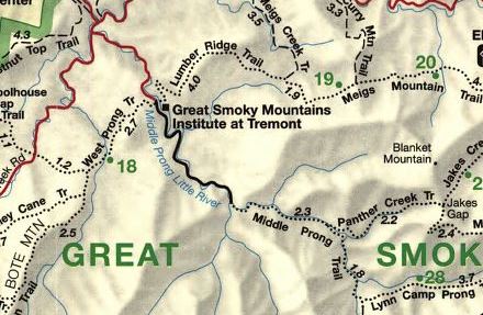
Middle Prong Trail Map
Middle Prong Trail Elevation Profile
Directions to Trailhead:
The Middle Prong Trail in the Great Smoky Mountains is located in Tremont, near Townsend. To reach the trailhead from the Townsend "Y" intersection, drive west on Laurel Creek Road towards Cades Cove. Roughly two-tenths of a mile from the "Y", turn left and drive 2 miles to the Great Smoky Mountains Institute at Tremont. From the Institute you'll drive another 3.1 miles along a gravel road to reach the Middle Prong Trailhead at the far end of the road.