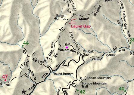
Balsam High Top Highlights
- Trail Features
Solitude, Quiet Forest Hike
- Trail Location
Straight Fork Road
- Roundtrip Length
7.6 Miles
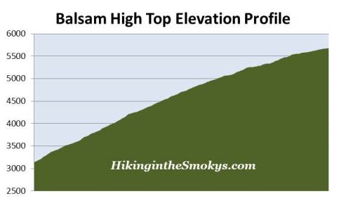
- Elevation Gain (total)
2535 Feet
- Elevation Gain (per mile)
667 Feet
- Trail Difficulty
12.67
Strenuous
This strenuous hike is 7.6 miles roundtrip and includes 2535 feet of elevation gain.
Balsam High Top Description
This hike to Balsam High Top begins from the Beech Gap Trailhead. During the summer months when the seasonal Balsam Mountain Road is open, hikers have the option of starting their hike from Pin Oak Gap and taking the Balsam Mountain Trail all the way to the summit. This would shorten your one-way distance by two-tenths of a mile, but more importantly, it would shave off 1275 feet of climbing. Hiking the Beech Gap Trail only makes sense if you don't want to travel along the one-way Balsam Mountain Road, or if you want the additional exercise / challenge, or if your visiting in April, May, or late October when Balsam Mountain Road is closed, and the Straight Fork Road is still open.
After walking only a few yards from the trailhead you'll reach a sign indicating that the Beach Gap Trail continues towards the right. Almost immediately after turning right the trail begins a steep climb up a very rocky and rugged path. During our mid-April hike we found that deep leaf litter made walking even more difficult, mostly due to it hiding loose rocks along the path.
This entire hike follows the Benton MacKaye Trail, a footpath that stretches nearly 300 miles through the Southern Appalachian Mountains, including 96 miles through the Great Smoky Mountains. The trail was designed in the tradition of the Appalachian Trail, which was the brainchild of Benton MacKaye, a forester and co-founder of The Wilderness Society.
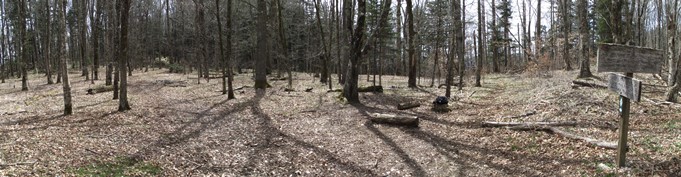
The trail makes a relentless climb up the southwestern slopes of Balsam Mountain, an immense mountain in terms of the amount of area it covers. The only break in the climb occurs at Beech Gap where the Beech Gap Trail dead-ends into the Balsam Mountain Trail, located roughly 2.5 miles from the trailhead. You'll know you're getting real close to the junction when the hardwood forest almost abruptly changes into an evergreen forest. At the junction are a few acres of flat terrain, making this a good place to take a break. You'll also be at an elevation of roughly 5070 feet, which means much of the climbing is already behind you at this point.
From the junction hikers will turn left onto Balsam Mountain Trail and begin traversing the ridgeline that heads northeast from Beech Gap, all the way to Balsam High Top. During our mid-April hike we saw hundreds of spring beauties sprinkled along the trail and hillsides just above the junction.
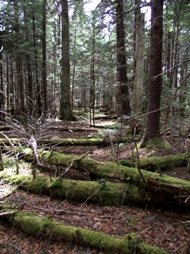
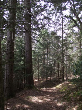
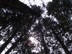
As the trail climbs higher it begins to travel into an older growth Spruce-fir forest - almost an enchanted forest, so to speak, due to all the greenery; not only from the trees, but also from the moss and ferns that grow along the forest floor.
At roughly 3.8 miles the trail finally reaches its highest point. Technically speaking, Balsam High Top sits about 20 or 30 feet above the north side of the trail. Unfortunately there are no views from the summit. In fact, there's really no payoff on this hike, only the solitude the trail has to offer, as well as the opportunity to hike through the Spruce-fir forest at the top. Along the ridgeline, as you approach the summit, are a few spots that offer a few glimpses into the surrounding mountains, but nothing with any big sweeping views.
From Balsam High Top hikers can continue on for roughly another half-mile to visit the Laurel Gap Shelter. However, there are no views from this campsite either.
Balsam High Top Map
Balsam High Top Elevation Profile
Directions to Trailhead:
From Cherokee, NC, turn to head east on Big Cove Road. Make note that at just over one tenth-of-a-mile the Big Cove Road makes a left turn off the main road. Continue on Big Cove Road for 9.3 miles, and then turn right onto Straight Fork Road. After about a mile you'll reach the Great Smoky Mountain National Park boundary where the road abruptly turns into a gravel road. Although narrow, this is a two-way road. From the park boundary continue on the gravel road for another 4 miles until you reach the second Beech Gap Trailhead. This is located past a fairly large automobile bridge, and just before reaching Balsam Mountain Road, which is a one-way road coming from the other direction. There will be a large gate here.
Please note that Straight Fork Road is usually open from early April through late October. (Balsam Mountain Road is usually open from late-May through mid-October)